

Below details a scenic drive from San Francisco Airport that I have driven dozens of times, when I lived in the Bay Area and visited. For a fun San Francisco hotel try Petite Auberge.
Scenic Drive From San Francisco Airport
After picking up my rental car (about 11am), it was a gorgeous day (like most September days in the San Francisco area) and I wanted to get to the ocean as soon as possible. My intended first stop was Ocean Beach, just north of Fort Funston.
When leaving San Francisco Airport, there are some surface street routes but most people head north or south on highway 101. I know that highway 280 is much prettier and less crowded than 101, so as quickly as I could, I want to get off of 101 and onto 280. Driving north on 101, turn west on 380 if possible but more likely south on 280 in a few miles. From either road (380 or 280), exit onto highway 1 south to Pacifica and then north on Skyline Drive (highway 35).
You will be greeted, during daylight, with a scene such as this. See the ocean?

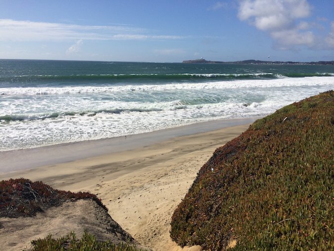
Stop 1: Ocean Beach
Just after passing Fort Funston National Park, turn left onto Great Highway. Nice name, huh? There are several places to stop before reaching the Cliff House and Sutro Baths at the northern end. I stopped at the southern end and had these views.

This is an ideal first stop after flying cross country and picking up a rental car. A nice alternate route from downtown San Francisco is Market Street west to Portola Drive to highway 35. This will take you through Castro District and Twin Peaks.

Stop 2: 16th Avenue Tiled Steps
Next I wanted to see the highly recommended 16th Avenue Tiled Steps project. The easiest route (from Ocean Beach) is Lincoln Way (right), highway 1 (right), Moraga Street (left), to 16th street entrance. I chose to drive smaller neighborhood streets until I found the Tiled Steps. Here is one picture.

For more pictures and information, please see my previously published article: 16th Avenue Tiled Steps.
Stop 3: Lunch in Sunset District (Outer Sunset)
After climbing up and down the steps, it was time for lunch. From meandering the smaller streets to get here, I saw a quirky neighborhood along Irving Street on both sides of highway 1. Looking at my Yelp app, I picked out The Taco Shop @ Underdogs.

I am always ready for a decent fish taco and people gave this place (and their tacos) rave reviews. There are many other interesting places in this area: ethnic eats, noodle houses, vegetarian. While waiting for my order, I snapped a few interior shots.

Stop 4: Fort Funston
Continuing my scenic drive from San Francisco Airport, I wanted to return to Fort Funston to eat my fish taco before heading south along the coast. From prior visits I knew Fort Funston was a great place to hang glide (and watch), hike, and ride horses.

The quickest and easiest route between the Tiled Steps and Fort Funston is south on 19th Street and turn right on Sloat Boulevard (highway 35). Say it with me: but of course I chose to drive smaller streets. Here is a view of the Golden Gate Bridge from around Moraga and 47th.
Stop 5: Devil’s Slide
I already packed a lot of exploring into a short time, so after eating and a quick walk, I was ready for a longer drive. I turned right onto Skyline Drive (35) and took the exit for highway 1 south.

Although there are nice beachside parks along 1, I did not stop until after the tunnel south of Pacifica (about 30 minutes from Fort Funston).

There is a convenient parking area, from where I took these pictures of the Devil’s slide area.

Stop 6: Point Montara
Continuing south on highway 1, this is gorgeous coastline and I recommend stopping at overlooks to take in the scenery. After the lovely small village of Montara is perhaps the most beautifully situated hostel in the world; anyone know of a prettier hostel location?


Stop 7: Fitzgerald Marine Sanctuary
Further south on highway 1, I passed the small town of Moss Beach and the Fitzgerald Marine Reserve. I turned around and I visited the marine reserve and was rewarded, after a short hike, with another scenic coastline beach. At the beach, I joined a handful of other people and watched some seals frolic in the chilly ocean water.


Stop 8: Half Moon Bay
Half Moon Bay, as most of these stops, are destinations where people can spend much more time. I have been to Half Moon Bay several times prior to this scenic drive from San Francisco Airport. On this trip, I opted to only stop at one of the lovely state beaches and a pumpkin patch.

Certainly you have heard of the world famous Half Moon Bay Pumpkin Festival?

Stop 9: Reservoir and San Mateo Overlook
Running out of time (pending dinner appointment in Cupertino), I had to make a decision. I could continue south on highway 1 to Santa Cruz and then take 9 or 17 through the Santa Cruz mountains into Silicon Valley. I love both roads. Even better, in this case, I decided to take Skyline Drive (highway 35) to 9 into Saratoga and then Cupertino. Fantastic road!
To get to Skyline Drive, turn left at highway 92 (San Mateo Road). It is “the” major turn in Half Moon Bay, so I know you will not miss it. You will pass some farms and farm stands (stop at them!) along 92 and then climb some hills. When you reach the junction with Skyline Drive, stop at the overlook in front of you on the right. Here is a view rom that overlook.

From the 92 / 35 junction, you can loop back to San Francisco by continuing on 92 to 280 (recommended) or 101 (blech!). You can also continue on 92 (past 101) across the San Mateo Bridge (fun!) to Hayward on East Bay side.
Stop 10: Purisima Creek Redwoods Open Space Preserve
Perhaps, just maybe, my favorite thing about this area are seeing redwood trees. Driving along Skyline Drive, there are overlooks with fantastic views of Silicon Valley (to the east) and toward the Pacific Ocean (to the west). There are some huge open space preserves and I decided to stop at a new one (well, new for me). Purisima Creek Redwoods Open Space Preserve just sounded peaceful. In spite of the inherent dangers, I survived a quick mile walk among the redwoods. I guess I really was scared of those listed dangers, because I have no redwood pictures from this hike.


Have you done this drive? Would you?
This place is absolutely wonderful, especially for a weekend getaway! Although I’ve never been there, I’m adding it to my bucket list right now!! Lovely pictures! :*
Thank you, Agness. I do hope you get to visit this incredible area soon.